Lidar
Lidar is a laser flown over the land. Its pulses pass through gaps in the forest canopy and record the ground below, so ruins under the trees show from the air (Chase et al., 2011, p. 387).
Caracol, 2009
Caracol spreads over most of the Vaca Plateau in western Belize, its parts joined by causeways (Chase et al., 2011, p. 388). Twenty-five years of work on foot had mapped about 23 square kilometers of settlement, more than 75 kilometers of causeways, and about 350 hectares of terraces (p. 389). An earlier test of lidar in Central America, in the 1980s, had not worked as well, and remote sensing in the Maya area turned to satellite images for a time (p. 389).
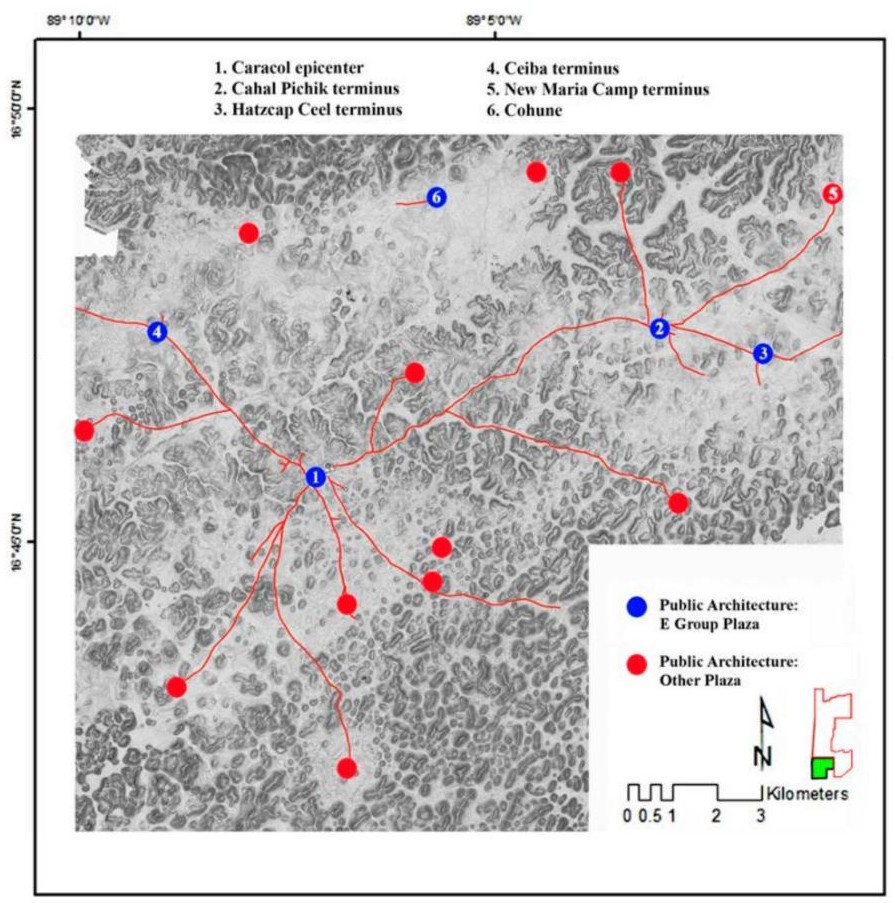
In April 2009 the National Center for Airborne Laser Mapping flew lidar over 200 square kilometers of Caracol (Chase et al., 2011, pp. 387, 390 to 391). A twin-engine Cessna carried the laser from April 26 to 30. The laser was on for a little over nine hours in 23 hours of flying. The flights came at the end of the dry season, when more of the leaves are off the trees (Chase et al., 2011, pp. 390 to 391).
Several days of flights and three weeks of processing showed more than the decades of mapping on the ground (p. 388). The images show that people had changed nearly 90 percent of the Caracol landscape. Terraces cover whole valleys and hills. About 15 percent more raised plaza groups appear in the images than the ground maps had found, because the forest had hidden them (p. 391).
Beyond Caracol, 2013
In April and May 2013 another 1,057 square kilometers were flown, so the city could be seen within its region (Chase et al., 2014a, p. 208).
Lidar of Tikal and the Petén comes to this page in December.
Still to check
- The cost of the 2009 survey to verify.
Sources
- Chase, A. F., Chase, D. Z., Awe, J. J., Weishampel, J. F., Iannone, G., Moyes, H., Yaeger, J., & Brown, M. K. (2014a). The use of LiDAR in understanding the ancient Maya landscape: Caracol and western Belize. Advances in Archaeological Practice, 2(3), 208–221. https://doi.org/10.7183/2326-3768.2.3.208
- Chase, A. F., Chase, D. Z., Awe, J. J., Weishampel, J. F., Iannone, G., Moyes, H., Yaeger, J., Brown, M. K., Shrestha, R. L., Carter, W. E., & Fernandez Diaz, J. C. (2014b). Ancient Maya regional settlement and inter-site analysis: The 2013 west-central Belize LiDAR survey. Remote Sensing, 6(9), 8671–8695. https://doi.org/10.3390/rs6098671
- Chase, A. F., Chase, D. Z., Weishampel, J. F., Drake, J. B., Shrestha, R. L., Slatton, K. C., Awe, J. J., & Carter, W. E. (2011). Airborne LiDAR, archaeology, and the ancient Maya landscape at Caracol, Belize. Journal of Archaeological Science, 38(2), 387–398. https://doi.org/10.1016/j.jas.2010.09.018
Every source the site uses is also on the Sources page. Links checked November 6, 2026.